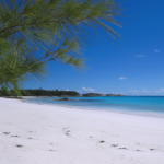
Eleuthera island is known for its famous and mostly deserted Eleuthera pink sand beaches of which it has 135. Additionally, it is very different from Atlantis – Paradise Island, Nassau – Bahamas and Exuma – Bahamas in that Eleuthera offers a myriad of beautiful and free natural attractions. This makes it not only unique and affordable, but also exciting and adventurous to explore.
What many travelers aren’t aware of are it’s numerous blue ocean holes. These seemingly bottomless salt-water filled cenotes connect to the ocean at some point and are scattered around the island. The majority of them are located towards the southern end of Eleuthera island. Most people are at least familiar with it’s most notable blue hole, The Ocean Hole, located in Rock Sound, Eleuthera. It was explored by none other than Jacques Cousteau who never found the connection to the ocean. But what about the other ocean blue holes on the island? Watch the video to learn my 5 favorite ocean holes and read the rest of the article to learn about the other Eleuthera island blue holes that I’ve explored on my adventures. This article contains GPS coordinates, descriptions, pictures and a few maps detailing their locations. It’s time to explore the island that Lenny Kravitz calls “Eleutheria”.
More--->- The Sapphire Hole in North Eleuthera is fast becoming one of the island’s favorite attractions. Visitors come to this blue hole to experience it’s 10 foot high jump into the crystal clear blue water below. This is also an interesting snorkeling site as the hole is home to Cuban Cave Shrimp. It can also be scuba dived to a depth of about 90′. GPS: 25° 33.220’N, 76° 42.342’W
RATING


2. James Cistern is a settlement on Eleuthera that also has an ocean hole bearing the same name. It was used as a water source when the US Navy had its facility near there in the late 50’s and 60’s. Today it is just an abandoned ocean hole that is too deep to enter and exit safely. It is also littered with debris and had a ‘pond scum’ type film covering much of it when I last visited. GPS: 25° 20.168’N, 76° 22.521’W
RATING


3. Ten Bay has it’s own small ocean hole that one of my neighbors nicknamed X10. For what reason? I have no idea! There is a small area to park, however, the hole itself is surrounded by extremely soft sediment. It is easy to sink in above your ankles. While I have not approached this hole closely I have seen divers in wetsuits exiting the water. GPS: 25° 7.034’N, 76° 8.736’W
RATING

4. Kemp’s Bay, just south of Ten Bay, has it’s own ocean blue hole, too, but it is extremely difficult to reach. I tried several times to cut my way through the brush, finally succeeding. Unfortunately, the part of the hole that I hoped to explore was on the opposite side from where I was standing and the muddy, silty bottom was almost quicksand-like so I opted not to venture far from shore. Alas, I seem to have misplaced my photos from the adventure. GPS: 25° 6.440’N, 76° 8.662’W
RATING

5. The Ocean Hole in Rock Sound is the most well known and visited blue ocean hole on the island. It has many varieties of fish and crustaceans living in it including angelfish, grey snapper, porkfish, blue tangs and blue mussels. It can be swam in and snorkeled. There are two ladders for easy entry and exit. Many visitors come here to feed the fish. Additionally, you can follow the walking paths to circumnavigate the hole and enjoy the native flora and fauna. There are signs in the settlement of Rock Sound on Queen’s Highway pointing the way to the hole and the hole itself is marked with signage and a gazebo making it very easy to find. GPS: 24° 51.839’N, 76° 9.332’W
RATING


6. The Boiling Hole in Rock Sound is interesting to look at with its abundance of lush shade trees enveloping the entire circumference of the hole, but it’s not a great place to swim or snorkel. There are a couple of caves on its opposite shoreline, but they are only for viewing rather than exploring. If you follow the path leading past the hole you will find the ladder that you can descend to The Cathedral (aka Spider) Caves. These two attractions are beautiful, very natural and worth visiting for an hour or two. GPS: 24° 51.248’N, 76° 9.376’W
RATING


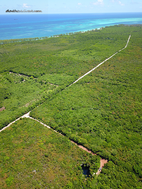
7. The Shrimp Hole earned its nickname due to the abundance of Cuban Cave Shrimp that I found inhabiting the water. The day I found this hole it was pouring rain and I had to cut my way back to it using a cutlass. The vegetation was tall and wet. It took me several tries before I actually found the edge of the hole and by the time I got there I looked like I had just come out of the shower. I must admit that I was a bit unprepared for the excursion. The rocky ironshore around the hole was extremely sharp and I couldn’t find a safe place to enter and exit the water. Additionally, the edge of the hole had a lot of soft sediment that I would have had to stand on in the water. I used my cutlass to sample the consistency and I went straight in up to my arm. Without a spotter I didn’t think it was safe to enter the water on my own so I left the full underwater exploration to a future excursion. Fortunately, I did have my underwater GoPro with me and was able to get a few short videos, which confirmed my belief that this was indeed an ocean hole since the organisms were ocean-like rather than pond-like. On the map below, the Shrimp Hole is the one at the top of the map. GPS: 24° 49.668’N, 76° 9.820’W
RATING
8. The Gwoupa Hole was another one that I had to nickname due to it having numerous large fish swimming in it including grouper. It had to be an ocean hole because the fish wouldn’t have survived in a brackish pond. The walls of the hole were 15′ to 20′ high and while there was a way to get to the water, it was not going to be an easy climb. I returned a second time to find out that the hole is on private property and that the fish were being stocked by the owner. Since it was farmland, the family that own it, and their workers, would eat lunch above the hole, feed the fish and sometimes fish for them, too. On the return trip we confirmed that there was a way to get to the water’s edge. It is hoped that in the future, land based tours can be organized to bring visitors to this hole for a swim. On the map below, the Gwoupa Hole is the one at the bottom of the map. GPS: 24° 48.774’N, 76° 10.512’W
RATING

9. Our last blue hole is nicknamed the Golf Course Blue Hole as it is found on one of the fairway cutouts of what was to be the “new” full size Cotton Bay golf course. I found it almost by accident as I drove back there one day to see the progress on the course. I hiked a few of the holes and came across the cutout of what was going to be a nice par 3 over a “pond” except it didn’t look like a pond. The water was way too blue and had the crystal clear sheen of the ocean. While I didn’t see any organisms, and couldn’t 100% say for sure whether it truly connected to the ocean, it had all the visual characteristics of an ocean hole. However, it didn’t look like one of those great deep blue ocean holes like most of the others. If not for the clearness of the water and its vibrant color I would have thought otherwise. See for yourself. GPS: 24° 47.270’N, 76° 10.976’W
RATING


While I’m sure there must be many more ocean holes on Eleuthera island, I have yet to find them. Eleuthera’s blue ocean holes can also be found in the ocean, too, but the ones I explored were deemed too dangerous due to shark activity so I will not be revealing them in this blog. I highly recommend putting on your adventure cap and taking a few rides into the jungle to experience these unique phenomena. I find them all interesting and hope that you do, too. While you’re enjoying the Eleuthera pink sand make sure to also take some time to enjoy Eleuthera’s blue holes.
Please remember to give this blog a Like and Share with all your friends. Thanks for reading!